InformNapalm: Russia’s territory shelled from occupied areas on February 19
The InformNapalm international volunteer community released the relevant evidence.
The community experts conducted an OSINT analysis of the shelling of the Russian border area in Rostov region, which occurred on February 19.
In particular, volunteers determined the exact geolocation of the multiple rocket launcher system from which the Russian territory was fired.
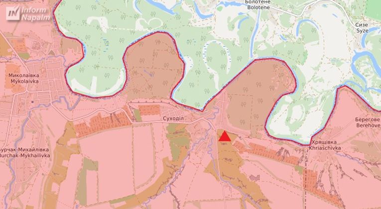
As it turned out, the shelling was carried out at 04:00 on February 19 from the village of Sukhodil, Luhansk region, which is controlled by Russian-occupation forces.
On February 19, the Russian media actively reported that the Russian Investigative Committee had opened a criminal case "for attempted murder committed in a generally dangerous manner due to Ukraine's shelling of the border area of Rostov region of the Russian Federation."

"Unidentified persons, being on the territory of Ukraine, using a multiple rocket launcher system, fired on the border area of Tarasov district of Rostov region," the Investigative Committee of Russia stated.
The next day, in order to strengthen the information drive, Russian propagandists of the NewsFront channel posted a video that allegedly confirmed the fact of shelling by Ukraine. Information about the shelling was accompanied by a video exclusive from a CCTV, showing a multiple rocket launcher system being fired.
Russian propagandists wrote that the shelling was conducted allegedly "from the northern side of the Siversky Donets River, near the village of Bolotene."

In the video released by the propagandists, the coordinates of the location of the CCTV were in the SK-42 reference system (so-called "rectangular coordinate system"), used only for military purposes.
"For people not familiar with the military affairs but engaged only in propaganda, these figures could seem insignificant. But military experts can easily transform these coordinates into WGS-84 system civilians know. In this system, these coordinates will look like 48°34'32.5″N 39°35'03.1″E," reads the report.
These are coordinates of Sukhodil village (called Pionerske before de-communization reform in Ukraine, this name is still preserved on Russian maps).
According to InformNapalm, the Liveuamap map shows that this territory has been out of the control of Ukrainian troops since 2014 and is controlled by the Russian-occupation forces. The line of territory control exactly coincides with the riverbed of the Siversky Donets River.
"The camera is mounted on a hill that dominates the area. The height of the camera above sea level is 76m (shown in the screenshot), which corresponds to the height of the hill. At 00:11 of the video, the camera captures the location of the second shot. Not only the smoke trail from the launcher booster is noticeable, but also the reflected cloud of dust and combustion products behind the mount," InformNapalm added.
From this point, it is physically impossible to observe the populated localities in the government-controlled territory located on the other side of the Siversky Donets River as closely as it is seen on the video and there are no such buildings.
At the same time, you can see in the video that the launch site is between the houses and the greenery.
"Thus, the coordinates of the location of the multiple rocket launcher system, which was fired on the Russian Federation, are in the temporarily occupied territory of Donetsk and Luhansk regions. From the southern bank of the Siversky Donets River. The video actually shows the missile path passing between the camera and the power line, the water also reflects behind, respectively, the fire is conducted from this bank of the river," InformNapalm summed up.
ol


